
Blagdon Local History Society
‘Geological surveys at Holt Farm, Blagdon’ presentation by Arthur Langley from YCCART - Wednesday 9th February 2022,.
Article by Mike Adams
In recent months, Yatton, Congresbury Claverham and Cleeve Archaeology Research Team (YCCCART) have been conducting geophysical surveying in two fields belonging to Holt Farm just below Blagdon Church. Following our formal AGM, YCCCART chairman Arthur Langley gave a report of their work and findings so far.

Fig 1. Siobahn Watson at work in the excavation in the fields adjoining Park Lane, Blagdon. The precise position of it remains a mystery to this date.
Our society originally learned about Romano-British remains being found in the fields from the notes of the Rev John Skinner (1772-1839), an amateur antiquarian and archaeologist. As Vicar of Camerton, he was able to spend considerable time indulging his interests. He described Romano-British artefacts being found in ‘Park Fields’. YCCCART were following up on earlier work done by villager and society member Siobhan Watson (Fig 1). They were unable to locate the place of her work as the reference points, which were Western Power poles, had been repositioned.
YCCCART began their work in their usual way with a LIDAR survey. Like RADAR but using pulses of laser light, raised areas show up as light areas in the output image and depressions as dark areas. The LIDAR image was then superimposed over the 1885 OS map and it became clear that many features on the image represented hedges that had been grubbed out. A grid of 30m x 30m squares was then superimposed on the map and adjusted to accommodate as many complete squares as possible.


Figure 2. Above: A walker conducting a gradiometry survey
Figure 3. Left: Interpreting the results can be rather a mysterious art.
Figure 4.Below: Many hands make light work. Hydrostatic levelling.
The grid was superimposed on an image of the field obtained from Google Earth. Points on the grid were then set on the ground with tapes and poles to begin a gradiometry survey which detects and plots variations in the Earth’s gravitational field. This is done by a walker carrying the equipment along each line of squares in turn (Fig 2). Only a few poles are needed, which are moved along as the work progresses by a helper at each end. The cross points are recorded using GPS, which enables second survey passes to made if necessary. The initial survey showed up a ’lot of noise’ implying there is plenty to investigate.

A first look at the gradiometry results revealed a number of features, one of which could be a ‘banjo enclosure’ – round with an entrance in the form of a long neck. Such an enclosure would date from between 400BC and 43AD. A resistivity survey followed in which the electrical resistance of the soil is measured and plotted. The method is particularly good in detecting walls on clay soils. First results show a number of circular and linear features (Fig 3). Plots from the two methods were overlaid and used in tandem – fading one out and the other in alternately. The suggested pipeline was given credence later in the discussion by Mary Mead, who confirmed that a pipe of some sort goes under that field.
A second field is currently being surveyed and a final report will be produced by Chris Short and Vince Russet, former County Archaeologist at North Somerset Council.
The talk continued with a look at other recent work by YCCCART. An electronic hydrostatic level was used on Mendip (Fig 4) to successfully trace a section of the Roman road from Charterhouse towards Banwell. The equipment can measure heights to within one millimetre relative to a metal reference plate. It is very useful for detecting these roads, which were constructed as an agger of stones or gravel which sloped from the middle to the edges to shed water.
Wemberham Roman Villa at Yatton was discovered in 1884 when workers carrying out drainage work came across tesserae indicating a Roman mosaic. The site was excavated and they were able to draw up a plan of the basic walls. With their modern equipment, YCCCART located a bottom end wall, which was previously unknown. The site has given up some artefacts (Fig 6). The mosaic was found in the original excavation but the two tesserae were found during a field walk prior to YCCCART’s survey. The section of wall was revealed in 2007 due to erosion by sheep.
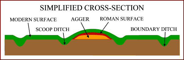
Figure 5. Cross section of a Roman Road

Figure 6. Left